“the only way i will allow a yankee to live. . . .”
James Montgomery-Ryan is a young man with a dream, and it’s on a schedule:
 when i see those images i see….the honor of our occupied nation and the other 2 images make me fightin mad an makes me want ta liberate dixie an take the war to the enemy an wipe the yankee scum from the face of the earth
im half blooded cheyenne and full blooded confederate and i can blame the yankees easily and subject them to the pain and suffering that my people have endured…im sick of the yankees occupying my country and if the yankees dont leave the confederacy by the end of july 2014 i will make sure that the yankees will be wiped from the earth because i will no longer stand yankee occupation or the yankee government selling confederate land to the chinese and russians will not stand
the only way i will allow a yankee to live will be if he/she swears alligance to the confederacy and serves for 10 years with distinction in the confederate army otherwise the only other choices are exile or death by firing squad
when i see those images i see….the honor of our occupied nation and the other 2 images make me fightin mad an makes me want ta liberate dixie an take the war to the enemy an wipe the yankee scum from the face of the earth
im half blooded cheyenne and full blooded confederate and i can blame the yankees easily and subject them to the pain and suffering that my people have endured…im sick of the yankees occupying my country and if the yankees dont leave the confederacy by the end of july 2014 i will make sure that the yankees will be wiped from the earth because i will no longer stand yankee occupation or the yankee government selling confederate land to the chinese and russians will not stand
the only way i will allow a yankee to live will be if he/she swears alligance to the confederacy and serves for 10 years with distinction in the confederate army otherwise the only other choices are exile or death by firing squad
I wonder if Charles Goodson knows about this potential recruit for his New Confederate Army.
__________

Friday Night Concert: The Monitor and the Merrimack
If you listen, I will tell you how so handy, O!
The Monitor went smack up to the Merrimack,
And upon her sides played, Yankee Doodle Dandy, O! Chorus: Hip a Doodle-Do, Jeff Davis, how are you?
Our Monitor beat your Merrimack quite handy, O!
Erricson he’s around; in the world, there can’t be found,
A people like the Yankee Doodle Dandy, O! ‘Twas on the Eighth of March, the Merrimack slipped out,
From Norfolk, for to take a cruise so handy, O!
She did not think, she’d meet any thing in our fleet,
Able to give her Yankee Doodle Dandy, O! She went rushing round, smashing everything she found,
Till the Monitor came sailing in so handy, O!
And Worden stopped her fun, soon made her cut and run,
While the shells they whistled, Yankee Doodle Dandy, O! For the Yorktown and the other, they’d be little bother,
To smash and break them both up so handy, O!
For our gunboats they would do to rip them through and through,
While the sailors they’d sing, Yankee Doodle Dandy, O! The Merrimack was some, till the Monitor she come,
And opened up her little ports so handy, O!
Then the shot did fly, till the Merrimack’s men did cry:
It’s the Devil sure, a Yankee Doodle Dandy, O! To Jeff this ought to show, that this Monster is no go,
And that Mechanics in the North, are very handy, O!
That he must surrender soon, or we’ll blow him to the moon,
With inventions of our Yankee Doodle Dandy, O! Now boys, let us cheer the men that don’t know fear,
That worked that little battery so handy, O!
They deserve well of us all, let us pray that none may fall,
May they live long to sing, Yankee Doodle Dandy, O!
________
U.S.S. Monitor Lab Work Suspended

Received this afternoon from the Mariners’ Museum:

Dear members of The Mariners’ Museum family, The Mariners’ Museum has made the difficult decision to temporarily close the 5,000-square foot lab that houses the USS Monitor‘s gun turret and other large artifacts following the Dec. 31, 2013 expiration of an agreement with the National Oceanic and Atmospheric Administration’s National Marine Sanctuary Program. Simply put, The Mariners’ Museum cannot continue to shoulder the conservation costs for these artifacts, which belong to the federal government. In 2013, the conservation cost was approximately $500,000. NOAA was only able to provide 10 percent of funding, and no funding was designated in 2012, the 150th anniversary of the Monitor‘s historic clash with the Confederate ironclad Virginia in Hampton Roads. The decision to close the “wet lab” does not impact the rest of the Museum operation. The Monitor exhibition Ironclad Revolution is still open, as is the rest of the exhibition space at The Mariners’ Museum. Also, though no progress in the artifacts’ treatment will be made during this period, the artifacts remain in a stable environment. This is an emotional move for all of us, who feel deeply invested in the effort to tell the important story of the USS Monitor through its artifacts. Most affected is our team of Monitor conservators, some of whom have dedicated years to this project, and who consider themselves the guardians of the Monitor. NOAA is waiting on Congress’ approval of a budget to determine what funding to make available this coming year. NOAA and The Mariners’ Museum are working together to ensure that funding is in place to continue this important conservation work. The lab will re-open once funding is secured. You can help us by letting legislators and NOAA know you believe the government should designate funding for the Monitor conservation project at The Mariners’ Museum. Here are three ways you can do this:Thank you for your support of our continued desire to tell the USS Monitor story, and to preserve these artifacts for many generations to come.
- Sign our change.org petition
- Message NOAA and The Mariners’ to let us know of your support
- Forward this e-mail to your friends
I don’t know what to add except that this is extremely discouraging. The amounts involved in this case are effectively a rounding error compared to most of the stuff the federal government does. It’s easy to believe that the federal agency with direct oversight of this project, NOAA, as the villain in this, but I don’t think they’re receiving the appropriations needed, either. (High-profile projects like Hatteras in 2012 have been underwritten by generous private donors, as the agency itself lacks the funds to do basic maritime heritage fieldwork as part of its mission.) It’s a bad situation.
__________
What City is This?

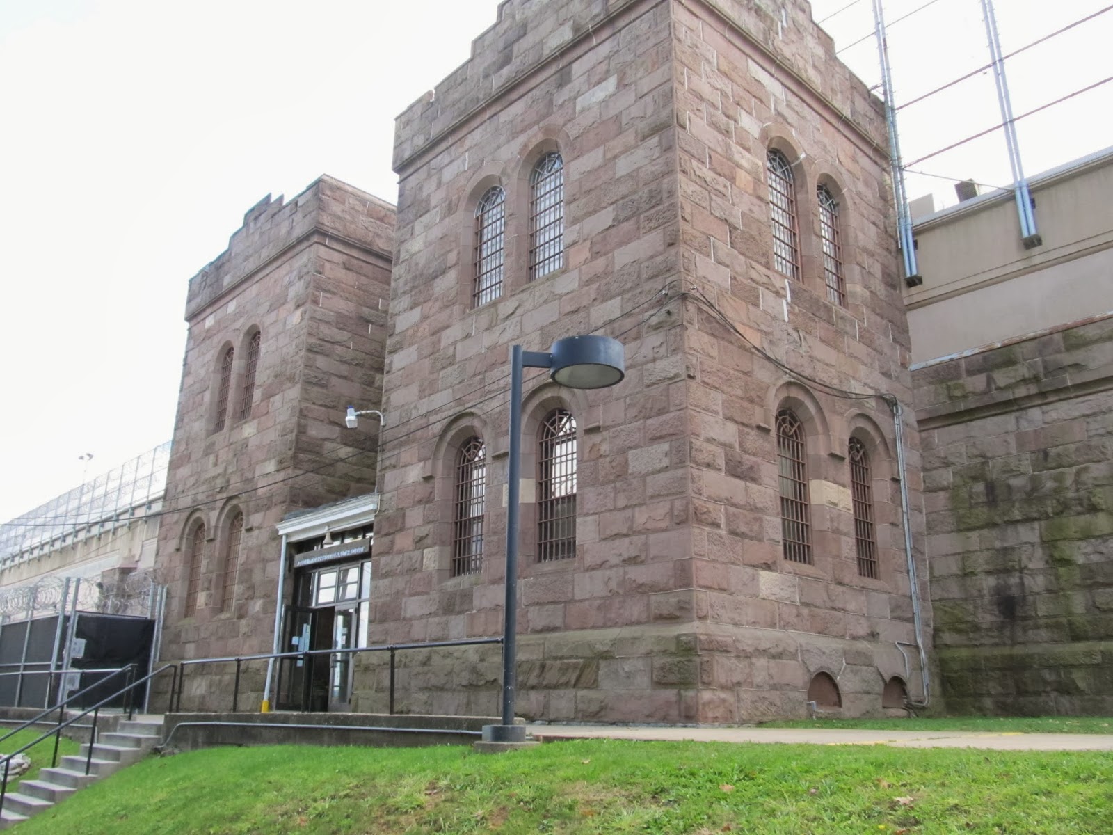
Update: January 6: A reader from Virginia notes that the structure with the tower looks a lot like the Old Northampton County Courthouse in Easton, Pennsylvania. It sure does. Perhaps more indicative, the structure immediately to the left of it matches the original entrance to the Northampton County Prison, next door. The prison was completed in 1871, which would date this image to sometime after that. If this identification is correct, and I believe it is, this view is looking roughly southwest from the hill where part of Lafayette College now stands, overlooking Bushkill Creek and Highway 22, the Lehigh Valley Thruway.
Well done! Thanks!

The Library of Congress has this image identified as Richmond, Virginia, and I’m pretty certain that’s wrong. Although there are some broad similarities between Richmond and the town in the photograph, the details are all wrong. Civil War-era images of Richmond are full of easily-identifiable landmarks, but none match this town. Folks who actually live in Richmond seem to agree — it’s not their city.
So what town is it? You can view a high-res version here. We discussed this over at Civil War Talk, and ran through a lot of possibilities — Vicksburg, Memphis, Nashville, Petersburg — none of them has a match for the building on the hill at left. I’m not even sure this is in the South — something about this says New England or upstate New York to me, but I could be wrong about that.
I’m not interested in running down folks’ guesses — done that already — so if you think you’ve got the answer, post a link to the evidence in the comments. For sure, somebody recognizes this town.
_________
A Blue Norther (Revisited)
 Galveston beachfront on the morning of January 3, 2014, with much more beach exposed than is usual, due to high, steady northerly winds.
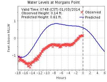
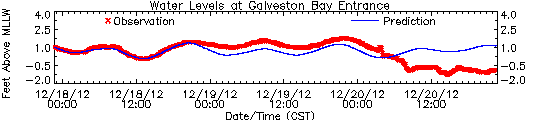
The same weather front that’s walloped the eastern United States over the last 48 hours has had its effect here on the supposedly-balmy Texas coast as well. The air temperature Thursday morning was in the mid-40s, but a sustain, 28 mph blast of wind from the north pushed the wind chill down to around freezing. The wind slacked a little during the day, but never let up completely. Sure enough, by overnight (January 2-3), the water in the upper part of the bay at Morgan’s Point had been blown down more than a foot (red Xs) from its predicted height (blue line) based on usual tidal cycles:
![]()
![]()
Under the circumstances, now seems like a good time to revisit a post I did about a year ago, on this somewhat unpleasant phenomenon.
![]()
Update, January 7: At around 8 a.m. on Monday, January 6 (“-16 hours”), the water level at Morgan’s Point was two feet below its normal level:

Cra. Zy.
In the winter of 1843-44, an Englishwoman by the name of Matilda Charlotte Houstoun (pronounced “Haweston”) visited Galveston twice with her husband, a British cavalry officer. The Houstouns were making a tour of the Gulf of Mexico, with Captain Houstoun trying to drum up interest in an invention of his for preserving beef. During their second visit, the Houstouns made a trip to Houston and back the 111-ton steamer Dayton, Captain D. S. Kelsey. On the trip back, the little steamer was delayed for two nights at Morgan’s Point, at the head of Galveston Bay, because a “norther” had blown so much water from the bay that it was impossible for the boat to get over nearby Clopper’s Bar, until the water rose again. The passengers went ashore and occupied their time in various ways; Captain Houstoun managed to shoot a possum, which was a novel creature to him. It was an object of brief curiosity until other passengers, more familiar with the fauna of Texas, appropriated it for the cook with the assurance that the animal was “first rate eating.”
![]()
 Morgan’s Point and Clopper’s Bar, as shown on an 1856 U.S. Coast Survey chart of Galveston Bay. The soundings are in feet; any unusual reduction in the water level in the bay would make the bar impassible.
![]()
“Northers” were new phenomena to the Houstouns, too, and in her travelogue Matilda Charlotte Houstoun gave a fine description of one:
They most frequently occur after a few days of damp dull weather, and generally about once a fortnight. Their approach is known by a dark bank rising on the horizon, and gradually overspreading the heavens. The storm bursts forth with wonderful suddenness and tremendous violence and generally lasts forty-eight hours; the wind after that period veers round to the east and southward, and the storm gradually abates. During the continuance of a norther, the cold is intense, and the wind so penetrating, it is almost impossible to keep oneself warm.
![]()
We had a norther here last week, a weather front that blasted through the area on the night of Wednesday/Thursday, part of the same front that caused hideous and deadly dust storms on the South Plains in Lubbock earlier. Down here, over 500 miles away, it left an orange dusting on cars and houses. Driving down to Angleton in Brazoria County along the Gulf on Thursday afternoon, my vehicle was continually buffeted by 25- to 30 mph winds, and an occasional higher gust, at a right angle to the road, pushing the car to the left, toward oncoming lanes of traffic. Not real fun.
But the most interesting aspect of this is one experienced by the Houstouns and others aboard Dayton almost 170 years ago, the effect of this strong, steady wind on local water levels. Historical accounts of bad weather will often include phrases like “blew the water out of the bay,” or something similar, and that’s not much of an exaggeration. Late Thursday evening, almost 24 hours after the front went through, I collected some graphics of meteorological and hydrologic data from Houston/Galveston Bay PORTS, a reporting system built and maintained by NOAA to provide real-time updates of conditions for those in the maritime industry. The graphics are small and a little difficult to read, but they provide direct, measured documentation of the sort of event described by so many mariners and travelers over the years. The data presented here are drawn from three different locations: Morgan’s Point, where Mrs. Houstoun and Dayton were stranded for two days; Pier 21 at Galveston, at the site of what was then known as Central Wharf, the steamboat’s destination; and Galveston Bay Entrance, a buoy along the channel through which marine traffic enters and leaves all the ports in the region — Galveston, Texas City, Houston, Baytown, and so on:
![]()

![]()
Let’s look at the data in some detail:
![]()
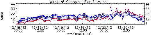
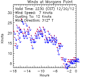 Wind speed at Morgan’s Point. This little chart shows the wind direction and speed for the period beginning about 4:30 a.m. on Thursday. The red dots show the sustained wind speed (scale on the y axis), while the blue arrows show its direction. For most of the period, right up until about 6 p.m., the wind blew steadily and consistently from the NNW at between 15 and 25 knots (17.3 to 28.8 mph), with gusts above that.
![]()
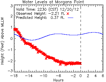
This chart shows the water levels at Morgan’s Point, from about 4:30 a.m. Thursday until late that evening. The narrow blue line represents the predicted height of the water at the tide gauge; it wavers a little bit based on the natural flow of the tide, which has a small normal range at that point. The red X marks are the actual, observed height of the water, which drops steadily with the wind over a period of about twelve hours, before leveling off and holding steady at more than two-and-a-half feet below the point known as “mean lower low water” (MLLW), the low-water standard that is used for navigational purposes. Note that the wind also wiped out almost any of the normal rise in the water level expected due to tidal action.
![]()
What about at the south end of Galveston Bay? Here’s the project vs. actual recorded water levels at Pier 21, along the Galveston wharf front:
![]()
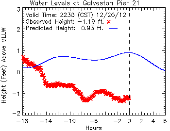 Here, closer to the Galveston Bay entrance, tidal action has more effect, but the water level remains more than two feet lower than predicted.
![]()
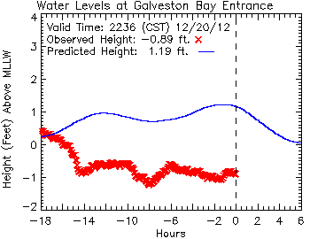
This chart, plotting data from a buoy at the entrance to the bay, reveals an almost identical profile to that from Pier 21. Here, again, eighteen hours after the passage of the front, the water remains more than two feet below its predicted level based on tides alone.
![]()
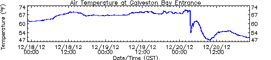
 These three charts show (top to bottom) wind speed and direction, air temperature and water levels at the entrance to Galveston Bay, for a 72-hour period ending about 10:30 p.m. on Thursday. Comparing these, it’s easy to see when the front passes in the early morning hours of Thursday, prompting dramatic changes in the wind, air temperature and water levels.
![]()
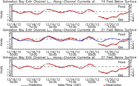 Finally, one last chart, showing the sub-surface currents at the entrance to Galveston Bay, at 14, 21 and 27 feet (4.3, 6.4 and 8.2 meters) below the surface. You can see the normal tide effect for the first 48 hours on this chart, as the current shifts between a flood tide (above the dashed line, water going into the bay), and an ebb tide (below the dashed line) as it flows out again. Although the wind only acts on the surface of the water directly, the momentum it generates there is carried through into much deeper water, dramatically altering flow of water so much that even at a depth of 27 feet, the normal tidal action is so completely erased that it results in a net ebb of the tide, a full eighteen hours of water emptying from Galveston Bay into the Gulf of Mexico.
![]()
How much water got “blown out of the bay” on this occasion? Some (very) rough estimates are possible. (Check my math, y’all.) If we take the difference between the predicted and observed water levels at the head of the bay (Morgan’s Point, -2.57 feet) and entrance to the bay (Galveston Bay Entrance, -2.08 feet), we can average between them a value of -2.33 feet. If we take that figure as representative of the water level of the bay as a whole (and that’s a big “if,” admittedly), then we can convert that vertical dimension into the volume of water it represents.
Galveston Bay encompasses about 600 square statute miles. One square mile is 27.88 million square feet; 600 square miles is 16.73 billion square feet. Multiply that by a depth of 2.33 feet, and you get a total volume of water of 38.98 billion cubic feet (1.1 billion cubic meters) of water.
That’s a lot of water; it would fill a cube-shaped aquarium 3,390 feet (1,033 meters), over a half-mile long, on each side. The water would weigh something on the order of 1.24 billion short tons, or 1.13 billion metric tonnes.
![]()
 A 3,390-foot cube of seawater, approximating the volume of water blown out of Galveston Bay during the norther on December 20, 2012. Shown to scale are (top) a large, full-rigged sailing ship similar to Cutty Sark, (right) the statue of Liberty, and (left) the Petronas Towers in Malaysia, among the world’s tallest structures.
![]()
So much for the numbers. What does this mean in practical terms for navigation on Galveston Bay? Today, weather conditions like these still pose a problem, particularly the wind, which poses significant challenges for large vessels transiting the Houston Ship Channel. I suspect the problem is worse for down-bound vessels than up-bound, as the former are running with the wind and current, and are thus much more difficult to maneuver.
In the mid-19th century, the challenges of foul weather on the bay were substantially worse. The riverboats that ran between Galveston and Buffalo Bayou, Cedar Bayou, or the mouth of the Trinity River were very vulnerable, with their high superstructures and chimneys to catch the wind from any angle. (The little sternwheeler C. K. Hall, carrying a load of bricks out of Cedar Bayou, was sunk in just such a situation in 1871.) But the bigger problem then, before major dredging operations had established a deep and stable channel, was the depth of water over obstacles like Clopper’s Bar and Red Fish Bar, a nine-mile-long oyster reef curving in a gentle, east-west arc stretching completely across Galveston Bay, almost exactly halfway between Clopper’s Bar and Galveston Island. Red Fish Bar could, on occasion, cause significant damage to vessels, and at least one steamboat, Ellen P. Frankland, would be wrecked on the obstruction in the 1840s. Both Clopper’s Bar and Red Fish Bar could be crossed regularly by vessels drawing less than four feet, but this depth of water varied with the tide and weather.
![]()
 Red Fish Bar, as shown on an 1856 chart of Galveston Bay. Soundings are given in feet.
![]()
I doubt that most of us in this area paid too much attention to the weather Thursday, apart from the inconvenience of the sudden drop in temperature and the wind. But it’s good to keep in mind how dramatically similar events sometimes affected the day-to-day lives of people in the past, and how fortunate we are to be sometimes that much more removed from them.
_____________

U.S.S. Westfield Exhibit Update

From the December 27 Houston Chronicle:
A 150-year-old Civil War ship and its contents is on its way to Texas City after being excavated from the bottom of the Houston Ship Channel and restored in a five-year project.The USS Westfield, which sank in the Battle of Galveston in 1863, was brought to the surface in 2009 in what was the largest maritime archaeological rescue project ever undertaken in Texas.Once up, archaeological conservators discovered hundreds of artifacts including belt buckles from the crew, boiler and engine parts as well as live ammunition.The star of the find is a 12-foot-long cannon, which could have fired projectiles over a mile and a half. [The gun is a IX-inch Dahlgren, the only one of Westfield’s guns not salvaged by the Confederates.]“This thing is a beast!” said Justin Parkoff, manager of the Westfield project at Texas A&M Conservation Research Lab where the restoration is taking place.
Early in 2014, that cannon will be sitting on a re-created carriage at the Texas City Museum.
Closer to summer comes a rebuild of the engine cylinder, and later in the year a massive reconstruction of the boiler. That will be so big it will reach the museum roof, Parkoff said.
“It will be a huge attraction,” said museum curator Linda Turner. “So many Civil War buffs will want to come and see it. It will be dramatic.”
Full story and lots more pictures here. Here is an image of Justin cleaning one of the boiler’s access hatches. The final phase of exhibition development will add a full-scale mockup of the boiler — half of it a modern reconstruction, and the other half assembled from original fragments recovered from the wreck. It’s gonna be fandanmtastic.

________
Dropping by to Borrow Some Dahlgrens
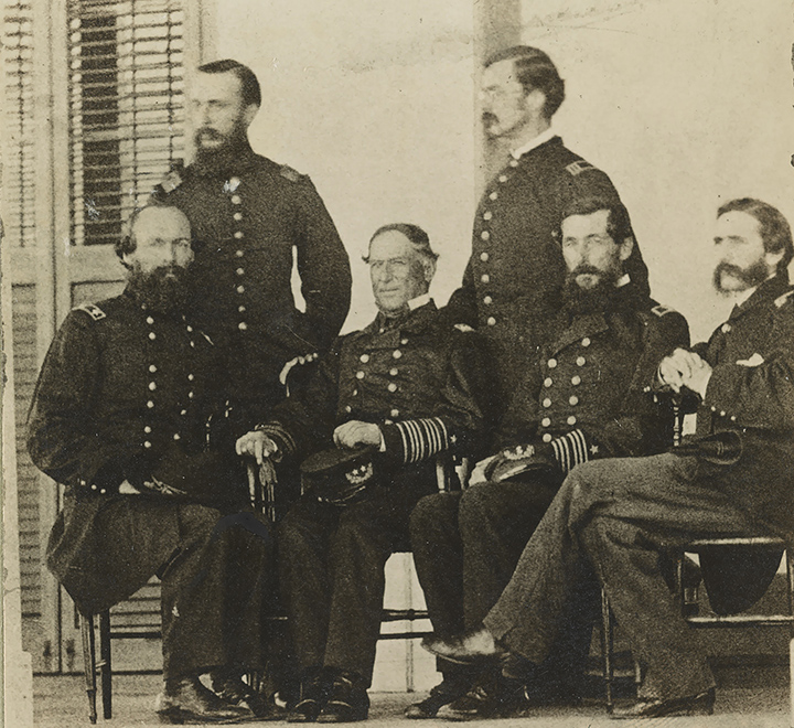
I found this image at LoC this evening. I’ve seen others taken at the same time, but not this combination of officers. The first three seated officers are (l. to r.) Army General Gordon Granger, Admiral David G. Farragut, and Farragut’s Flag Captain, Percival Drayton (of the Drayton Hall Draytons, natch). The fourth seated officer and the two standing, I don’t know. Only Farragut is identified on the LoC site.
The LoC caption is a garbled mess:
![]()
![]()
What I believe it shows is a meeting on the porch of the Commandant’s House at Fort Gaines, discussing the placement of Hartford‘s IX-inch Dahlgrens on the rear (east) side of Fort Morgan, to assist in the siege of that position. This would date the photo between August 8, 1864, when Gaines fell, and August 22, when Granger’s troops began their bombardment of Fort Morgan. Farragut and Granger got on fairly well; the admiral wrote of the general, “Granger is more of a man than I took him for, [he] attends to almost all the work so far as keeping others up to their mark.” The navy eventually lent Granger four Dahlgrens, with crews to man them from Hartford, Brooklyn, Lackawana and Richmond. Farragut also sent Lieutenant Herbert Tyson from Hartford to take charge of the guns on shore, so possibly Tyson is one of the other officers shown. The four naval guns were placed in two positions, about 1,400 and 1,500 yards from the fort’s walls, collectively designated “Battery Farragut.”
 Update, December 31: The meeting must have been prior to August 19, as well, because on that date Drayton (right) mentioned the planned battery when he wrote to an old friend, warning him not to be taken in by over-optimistic speculation in the North about the Mobile campaign:
.
However your neiqhbours feel, don’t allow yourself to be too sanguine about [the capture of the city of] Mobile. Fort Morgan has at least to be taken first, as until then not a man can be spared for anything else. We are getting a naval battery of four nine inch guns to bear upon it, but you know how difficult breaching is where the glacis entirely protects the scarp, and if the garrison has any endurance, the place must be carried by regular approaches and finally assault. At least our passage of the forts is the single piece of good luck this year. Everywhere else we have either been beaten or remained pretty much at a stand off..
Morgan actually fell four days later, without the assault anticipated by Captain Drayton, saving a great many lives on both sides.
___________
Friday Night Concert: “I Goes to Fight Mit Sigel”
“I Goes to Fight Mit Sigel” is a song that both celebrates and pokes gentle fun at the large number of German immigrants that served in the Union army. Sigel, of course, is Franz Sigel, a former Baden Army officer who had been caught up on the wrong side of the 1848 Revolution, and eventually became one of the German Forty-eighters who emigrated to the United States.
Sigel was one of Lincoln’s “political” generals, and though he didn’t make much of a field commander he was very successful in calling his fellow immigrants to Union arms, and in building the Army of the Potomac’s German regiments into a cohesive fighting unit. That is a significant contribution on its own.
![]()
I goes mit regimentals,
To Schlauch dem voes of Liberty,
Like dem ole Continentals
Vot fights mit England, long ago,
To save dat Yankee Eagle;
Und now I gets mine sojer clothes,
I’m going to fight mit Sigel. Chorus: Ya! Das ist drue, I shpeaks mit you,
I’m going to fight mit Sigel. Ven I comes from der old Countree,
I vorks somedimes at baking;
Den I keeps a lager bier saloon,
Und den I goes shoemaking;
But now I was a sojer been
To save dat Yankee Eagle;
To give dem Rebel vellers fits, I’m going to fight mit Sigel. Chorus: I gets ein tam big rifle guns,
Und puts him to mine shoulder,
Den march so bold, like a big jack-horse,
Und may been someding bolder;
I goes off mit der volunteers,
To save dat Yankee Eagle;
To Schlauch dem tam Secession volks,
I’m going to fight mit Sigel. Chorus: For rations dey gives salty pork,
I dinks dat was a great sell;
I petter likes de Sour Kraut,
De Schnitzel Kaize und Pretzel.
If Fighting Joe will give us dem,
Ve’ll save dat Yankee Eagle;
Und I’ll put mine Frau in breechaloons,
I’m go un fight mit Sigel. Chorus: Dem Deutshen mens mit Sigel’s band,
At fighting have no rival;
Un ven Cheff Davis’ mens we meet,
Ve Schlauch em like de tuyvil;
Dere’s only one ting vot I fear,
Ven pattling for dat Eagle;
Ve vont get not no lager bier,
Ven ve goes to fight mit Sigel! Chorus:
__________
Mapping Speech
![]()
 So said Henry Higgins in the first act of George Bernard Shaw’s Pygmalion. The New York Times Sunday Review has a short, 25-item quiz on vocabulary and pronunciation of specific words, that compares users’ speech to that of other people around the United States.
According to the survey, my own vocabulary and pronunciation is closest to other folks that live in the area shown in dark red:

The major cities my speech most closely matched were Houston (“feeder road” is apparently a term unique to the Houston metro area), Baton Rouge, and New Orleans. Users should remember that this survey doesn’t claim to predict where you’re from, but how similar your pronunciation and usage are to people in different parts of the country. Still, for me, that looks about right. How about you?
____________
Image: Julie Andrews and Rex Harrison in the Broadway production of My Fair Lady.


4 comments