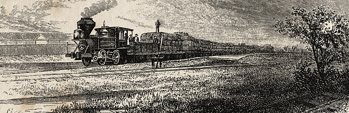
“The passengers got the full benefit of the sparks, cinders and smoke”
On another forum we’ve been discussing the logistical challenges faced by the South during the war relating to railroads. My colleague David Bright argued — correctly, I think — that the fundamental problem was not just in the relatively limited amount of rail transport extant in the Confederacy at the beginning, but in the inability to expand or even properly maintain what they had at the start:
In my opinion, more serious were: insufficient rolling stock, lack of manpower in the CSA such that the railroads (and their supporting infrastructure — mines, foundries, etc) could not get the manpower they needed, and the inability to replace anything that was lost (rails, rolling stock, depots, etc).
Dave’s observation reminded me of a passage in a history of Houston by S. O. Young (1848-1926), who was a teenager during the war and who later wrote extensively on local history:
There were many difficulties to be overcome in the way of transportation and equally as great ones in obtaining money or credit to pay for construction. Just as the Harrisburg road got under good headway; the Houston and Texas Central got into the game. The first shovel of dirt for this road was thrown by that great railroad genius, Paul Bremond, in 1853. When he threw up that dirt he turned up more trouble for himself than generally falls to the lot of one man. Of course, he did not know this, but I am convinced that had he done so it would have made not the slightest change in his plans. His faith in himself and his confidence in his ability to accomplish whatever he started out to do, was something sublime. When it came to energy he had any engine on his road faded to a standstill. He was a wonderful man, and he did not hesitate, at times, to attempt the apparently impossible. When his first contractor got cold feet and threw up his job, Mr. Bremond promptly undertook to carry out the contract to build the road himself. There is where his troubles began.
More on the Petersburg Photo

![]()
Ben Uzel, President of the Colonial Heights Historical Society who identified the location of the Petersburg photo the other day, follows up:

 The second attachment is a photo showing what the site looks like today. The southern river channel was filled in and is now covered by the Norfolk Southern track and a parking lot. Hope this adds to the interpretation.
![]()
It does indeed. Thanks!
______________

Petersburg Photo Update

Recently we had a discussion about this LoC photo, taken in the “Petersburg vicinity” at the close of the war. Tuesday evening I received this update from Ben Uzel, President of the Colonial Heights Historical Society, opposite the Appomattox River from Petersburg. I’m reposting his comment here, with permission:
Here’s the Harper’s Weekly image of Petersburg mentioned, via SonoftheSouth.net:

_______
Stuck at Hanover Junction

Passengers at Hanover Junction, Pennsylvania, one of several images in the Library of Congress collection. I believe these pictures were taken on November 18 or 19, 1863, and may depict passengers stuck at Hanover Junction, unable to continue on to their intended destination at the dedication of the new National Cemetery at Gettysburg. See an enlargement here.
UPDATE: Scott Mingus got there first.
![]()
We talked the other day about the logistical difficulties of rail travel through wartime Richmond, Virginia, which was served by fine railroads, none of which connected to any another. As I mentioned in the piece, that was a common situation in the 1860s, across the country. As Bob Huddleston mentioned in the comments on that post, it was exactly that sort of situation in Baltimore that required the 6th Massachusetts to march through the center of that city, exposing them to mob violence in April 1861.
There’s another example of how disjointed rail travel could be in those days.Hanover Junction, Pennsylvania was a stop on the Northern Central Railway, that ran north from Baltimore, Maryland, into the middle of the Keystone State. It was the connection point with the Hanover Branch Railroad (also known as the Hanover and Gettysburg), that ran the 25 miles or so west to Gettysburg. From a history of that little railroad:
This original trackage of the Hanover Branch Railroad became one of real historical interest. It carried the parties of President Abraham Lincoln and Pennsylvania Governor Andrew Curtin from Hanover Junction to Gettysburg on November 18, 1869, where on November 19, President Lincoln delivered his now famous “Gettysburg Address” at the dedication of the National Cemetery. The Northern Central trains carried President Lincoln from Baltimore and Governor Curtin from Harrisburg, the two groups meeting at Hanover Junction and proceeding together on the Hanover Branch to Gettysburg.
![]()
Simple enough, but there’s more to the goings-on at Hanover Junction during the Gettysburg dedication than that. It’s one of those stories that gets forgotten in the celebration, unless it happened to you. From the Harrisburg, Pennsylvania Patriot, November 26, 1863:
![]()
The Gettysburg Celebration. Dedication of the Great National Cemetery.In company with many others, we took the train for Gettysburg, via Hanover Junction, on Wednesday morning, to swell the ranks of the thronging thousands who, prompted by curiosity and patriotism or drawn by the tender ties of love for the dead, were gathering there to witness and participate in the the grand and solemn consecration of the burying place of the nation’s dead. . . .The train n which we rode was filled to its utmost capacity, many being forced to stand on the platform throughout the journey. The passengers were from all parts of the country, and almost every loyal State was represented in each car. The accommodation of the roads — the Northern Central and the Hanover and Gettysburg — were by no means sufficient for the occasion, and all persons going to or from the scene of interest were put to great inconvenience in consequence. Some were unable to get beyond Hanover Junction on Thursday. We saw a party of over fifty persons, who had journeyed over six hundred miles for the express purpose of attending the dedication, which party lay at the Junction from nine o’clock in the morning until ten at night, unable to get a step farther. Not a train was run over the Hanover road during that time, and this the pilgrims, after coming six hundred miles to see the battlefield, were defeated in their enterprise on the last twenty-five miles. It is a matter of wonder that, with such timely notice, this road failed to make proper arrangements, and suffered the spirit of mismanagement to paralyze its workings.
![]()
There are additional photos at the Library of Congress, apparently taken at the same time, of Hanover Junction. Some are attributed to Matthew Brady, and some assigned a date of 1863, but nothing more specific:
 See an enlargement here.
 See an enlargement here.
![]()
The LoC catalog listing provides no additional information on the date or subject of these images, but there are clues. The lack of vegetation on the trees suggests the images were made either early or late in the year. The clothing of the civilians is uniformly heavy, and mostly formal — these are not locals hanging around the depot to see who gets off the train. The soldiers all seem to be using canes, suggesting the effect of wounds. To me, these factors all suggest a date in late 1863. More specifically, I believe all three images are of parties traveling to or from the dedication of the National Cemetery at Gettysburg on November 18 or 19, 1863 — maybe Governor Curtin’s party, or perhaps the delegation that had come 600 miles to witness the festivities, only to find themselves stuck in Hanover Junction. Either of those would be obvious subjects for a photographer. I don’t know if Brady traveled from Washington to Gettysburg, but Alexander Gardner was there. He had broken with Brady and had his own studio in Washington by the fall of 1863, and Gardner likely would have followed the same route by rail from Washington to Gettysburg, changing at Hanover Junction. Could these be Gardner photos from that event, misattributed (as much of his work was) to Brady? Or did Brady, coming up from Washington, also found himself stuck at Hanover Junction on the day of the dedication, and occupied his time shooting images of his fellow stranded passengers?
The 1863 station at Hanover Junction, by the way, still stands, apparently little changed from its appearance 150 years ago (via Google Maps):


![[Download full size here.]](https://deadconfederates.com/wp-content/uploads/2013/08/1877-map1.jpg)
leave a comment