Private Kirkland, Battery D, First Missouri Light Artillery

A postwar image of part of Wilson’s Creek Battlefield, believed to be the cornfield behind the Ray family springhouse. Image via Wilson’s Creek National Battlefield; WICR 31376.

Like probably a lot of people, I was surprised by the scene in Lincoln where Elizabeth Keckley, Mary Lincoln’s modiste and confidante, says to the president, “as for me: my son died, fighting for the Union, wearing the Union blue. For freedom he died. I’m his mother. That’s what I am to the nation, Mr. Lincoln. What else must I be?”
I was unaware that Keckley’s son had died as a Union soldier, but it’s true — at Wilson’s Creek, in 1861. Over at The Sable Arm, Jimmy Price has the details.
___________

Buster Keaton is “Mooching Through Georgia”
 Everyone knows the classic, blockbuster film Gone with the Wind. Even before it premiered in Atlanta in December 1939, the film adaptation of Margaret Mitchell’s novel was becoming infamous in Hollywood for its cost over-runs, changes in directors (Victor Fleming, George Cukor, Sam Wood), and difficulties in casting — Clark Gable wasn’t cast as Rhett Butler until shooting had already begun. In 1939 Gone with the Wind was the talk of Hollywood, and not in a good way.
It’s not surprising, then, that MGM’s competitors would jump at the chance to poke fun at David O. Selznick’s over-budgeted and over-hyped historical drama, even before it opened. Columbia Pictures released this short, Mooching Through Georgia, in August 1939. There’s nothing especially noteworthy about this effort apart from from its context in Hollywood’s studio wars. The comedy here is crude slapstick; both the director, Jules White, and the screenwriter, Clyde Bruckman, mostly did Three Stooges shorts. It’s almost an embarrassment for its headliner, Buster Keaton, whose 1927 performance in The General is a classic of physical comedy. And the action, such as it is, all takes place in Kentucky, not Georgia.
Call it a footnote — a very small and mostly forgettable footnote — the cinematic history of the Civil War.
___________
Image: Buster Keaton and Ned Glass in Mooching Through Georgia, 1939.
Bluffing J.E.B. Stuart

After Christmas 1862, Robert E. Lee ordered his cavalry commander, J. E. B. Stuart, to conduct a large-scale raid north of the Rappahannock River, with the intent that Stuart would both collect as much intelligence as he could, as well as cause as much confusion and destruction as possible behind enemy lines. This was exactly the sort of thing that Stuart excelled at; he took 1,800 troopers and a battery of horse artillery along. Stuart’s expedition got to within four miles of Fairfax Court House but, upon meeting unexpected resistance, halted his advance and then slipped away toward Confederate lines. In this letter, written 150 years ago today, Lieutenant Colonel Charles Fessenden Morse (1839-1926), an officer in the 2nd Massachusetts Infantry, offers an explanation that helps explain Stuart’s reluctance to press the attack:
![]()
![]()
Morse goes on to disappointment at the lack of commitment and urgency at winning the conflict of his fellow Northerners, compared to the population of the South:
![]()
![]()
Image: “Stuart’s Christmas Raid” by John Paul Strain.

“It seemed the choked voice of a race at last unloosed”
 Emancipation Day ceremonies with the 1st South Carolina Infantry, Camp Saxton, Port Royal, South Carolina, January 1, 1863. Frank Leslie’s Illustrated Weekly.
Contrary to claims often made, when it formally took effect on January 1, 1863, the Emancipation Proclamation immediately freed thousands of enslaved persons across areas of the South then occupied by Federal forces. As Eric Foner outlined in his Pulitzer Prize-winning history, The Fiery Trial: Abraham Lincoln and American Slavery, one of the most important of these was in the Sea Islands along the South Carolina and Georgia coasts, territories that were still nominally in rebellion but had taken by Federal forces early in the war, to use as a staging position for further campaigns up and down the coast. And in the Sea Islands, there was probably no bigger celebration than at Port Royal, South Carolina, where a formal ceremony was held by, and for, the first black regiment in the Union Army, the 1st South Carolina Volunteer Infantry (later re-designated the 33rd USCT). The event was so dramatic that it forms the opening scene of Stephen Ash’s history of the 1st and 2nd South Carolina, Firebrand of Liberty.
Today, on the sesquicentennial of that event, we have three first-hand accounts of that celebration — one from an African American woman, an escaped slave, employed by the regiment as a laundress; a white abolitionist woman from New England, who had come to the Sea Islands to do volunteer work with the Freedmen and -women there; and the white officer commanding the 1st South Carolina.
Galveston’s City Market

![]()
I recently came across this stereoview of Galveston’s Civil War-era central market, at the Lawrence T. Jones III Collection of Texas Photographs at SMU. It’s taken at the intersection of 20th Street and Avenue D, which latter street is known as Market Street because of this facility. The SMU catalog dates the image to the decade of the 1880s, but I believe it may be earlier; it was replaced by this French Renaissance, Disney-esque pomposity, designed by Alfred Muller, in 1888. The later structure was heavily damaged in the 1900 Storm, but elements of it survived into the 1960s. You can view a merged sequence of the site then and now, here.
![]()

The narrow strip of property, in the middle of 20th Streets between Avenues B (now Strand) and D (now Market), was obtained by the city in late 1845, as one of the last acts undertaken by the city during the period of the Republic of Texas. The market was built in 1846, with stalls on the ground floor for vendors. Municipal offices and City Hall were located on the second floor. The earliest image of the market may be from 1861, when it was captured (above) in one of a series of images taken from the top on the Hendley Building (image from Rosenberg Library, Galveston).
The City Hall on the second floor of the market served as a meeting place on the evening of October 8, 1862, when those citizens who chose not to evacuate the city during the impending Union occupation elected J. W. Moore, the oldest magistrate in the county, to serve as the city’s mayor pro tempore during the crisis. The market would have been a dangerous place to be early on New Year’s Day 1863, as it was close to some of the fiercest fighting. General Magruder fired the first shot in the action from a spot just a couple of hundred yards up 20th Street; Magruder, who had a flair for the theatrical, pulled the lanyard on the gun, which was aimed at the Union gunboat Owasco, anchored in the harbor. The gun went off with a roar, after which Magruder turned to the artillerymen standing nearby and said, “I have done my best as a private; I will go and attend to that of a general.” In the heated (and largely blind-firing) exchange that followed, many buildings were struck by shellfire; the city market undoubtedly took its share of hits.
![]()

The city market appeared in Theodore R. Davis’ illustration of Galveston, published in Harper’s Weekly in the fall of 1866 (above), and in a well-known “birds-eye” view of the city published in 1871 (below).

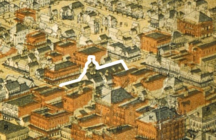
Then the city market made one final appearance in another birds-eye view of the city published in 1885 (above). The old wooden market building was no doubt showing its age by then, particularly when compared to the myriad, multistory brick structures that had sprung up around it in the postwar decades. It was nearly forty years old by that point, and there was probably also a need for much more space for municipal offices — Galveston had grown from a population of about 5,000 in 1850 to more than four times that number in 1880.
Finally, here are 3D versions of the Jones Collection image, optimized for both red/cyan glasses and for web viewing:

![]()

![]()
_________
Tony Kushner Explains Emancipation
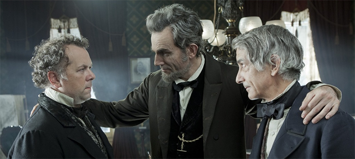
Lincoln (Daniel Day Lewis) confers with (l.) U.S. Representative James Ashley (David Costabile) and Secretary of State William Seward (David Strathairn) on strategy for passing the 13th Amendment.
![]()
I went to see Lincoln again on Thursday afternoon. It’s been playing here almost a month, but the matinee showing I attended Thursday was about as full as the first time I went, soon after it opened — only a few, scattered empty seats. It seems to be doing well, and it deserves to. The first time around I missed the opening scene, with the soldiers reciting the Gettysburg Address, that so many reviewers found clumsy and heavy-handed, and was ready to be turned off by it. In fact, I think it “works,” at least from the perspective of the average, non-history-nerd movie-goer, because it captures the moral core of what the Civil War had become for many in the North by the last few months of the war, and effectively frames the main narrative of Spielberg’s film.
One reason I wanted to go back was because I wanted to revisit some of the dialogue that seemed particularly sharp. One of these scenes appears relatively early in the movie, when Lincoln explains to his cabinet why he’s chosen to fight for the 13th Amendment now, during a lame-duck session of the House of Representatives whose members had previously voted it down, instead of waiting until the fall and beginning of a new Congress, when an expanded Republican majority in the House should be able to pass it easily. The time is now, Lincoln argues, because the war will soon be over, and with it his expanded authority as commander-in-chief. In this discussion, Lincoln acknowledges that Emancipation Proclamation was a wartime measure — a “military exigent,” his Attorney General calls it, and “slippery” according to Lincoln himself — that would be uncertain to survive review by the civilian courts once the wartime necessity of it had passed. He also acknowledges that as a result of the war — a far more desperate and prolonged conflict than any previous since the adoption of the U.S. Constitution in 1789 — no one really knew what the limits of executive power were in wartime, and (as with the legality of secession itself) those things were even then being sorted out. That’s why, Lincoln felt, the Thirteenth Amendment had to be passed and sent to the states for ratification immediately, to make permanent the provisions the Emancipation Proclamation had made temporarily, by force of arms.
Tony Kushner’s script brings all this out in that scene with Lincoln and his cabinet, where in a bit of expository dialogue, the 16th President lays out the legal and political terrain of emancipation. The discussion here is between Lincoln and John Palmer Usher, his Secretary of the Interior, and James Speed, his new Attorney General.

![]()
I wish Tony Kushner would spend some time writing K-12 lesson plans. Not many young people, it seems to me, have any concept of the complexity of this stuff, and it seems like it mostly doesn’t get covered very well. That’s all our loss.
__________
Charles Durning (1923-2012)
Charles Durning passed away on Monday. Most will remember him as a long-time character actor, one who specialized in playing blustery, somewhat-befuddled roles.
During World War II he landed at Normandy on D-Day, was wounded there, and later was taken prisoner during the Battle of the Bulge. He earned three Purple Hearts and a Silver Star, but even years later refused to speak publicly of those events. “Too many bad memories,” he told an interviewer in 1997. “I don’t want you to see me crying.”
He often played a “heavy,” but particularly seemed to relish his occasional comic turns. Durning was nominated twice for an Academy Award for Best Supporting Actor — in 1983, for playing the Texas governor in the film version of The Best Little Whorehouse in Texas, and again the following year for his performance as the bumbling Colonel Erhardt in Mel Brooks’ To Be or Not to Be.
This clip from The Best Little Whorehouse in Texas, most of which was actually shot inside the State Capitol in Austin, always makes me smile:
____________

Christmas Picket
 One hundred fifty-one years ago today, a nineteen-year-old Confederate soldier named Valerius Cincinnatus Giles (right, 1842-1915) went out on picket duty along the Potomac.
On Christmas morning a detail of twenty men was sent from the Fourth Texas Regiment to relieve the picket guard along the river. This detail was commanded by Lieutenant R. J. Lambert. The post assigned me was on Cock Pit Point, about 100 yards from the masked battery. This battery of four guns was planted twenty feet back from the edge of the bluff, completely hidden from view by an abatis of pine brush felled and stacked, with the sharpened ends of the trunks pointing outward. as a crude defense. From my post I had a splendid view of the river for two or three miles in each direction. The low range of hills on the Maryland side opposite were covered with white tents and log cabins, the winter quarter of General Daniel E. Sickles’s New York Brigade. The war had just fairly begun, and this was new to me. The novelty of the situation, the magnificent view before me, the river rolling majestically along between white hills and evergreen pines so charmed and captivated me at first that I felt not the bitter cold. The snow was gently and silently falling. deepening 011 the hills and valleys, melting as it struck the cold bosom of the dark river. I had been on post but a short time when I beard the signal corps man sing out from the crow’s-nest high up in a sawed-off pine tree, saying to the officer in charge: “Look out, Lieutenant, a gun boat is coming down the river!” I could hear the artillery officer giving orders to his men, but from my position I could not see them. Looking up the river I saw a cloud of black smoke rising above the tops of the trees. All was excitement at the battery. and I could hear the artillerymen ramming home their shells, preparing to sink the approaching boat. Directly the steamer turned a bend in the river with volumes of black smoke pouring from her smokestacks. She was in the middle of the stream, coming dead ahead under full steam. It was really a disappointment to the fellows at the battery as well as myself, when the soldier in the crow’s-nest called out again: “0h, pshaw, Lieutenant, don’t shoot! She’s nothing but an old hospital boat, covered over with ‘yaller’ flags.” Of course a Confederate battery would not fire on a yellow flag any more than on a white one. The boat came steadily on down the river until she got nearly opposite Cock Pit Point, when she blew her whistle and turned toward the Maryland shore. As she made the turn she came within 200 yards of the Virginia bank and I could distinctly read her name on the wheel house. It was the old Harriet Lane. named in honor of the accomplished niece of President James Buchanan, who was queen of the White House during the administration of that eccentric old bachelor. In the winter of 1861 the Harriet Lane was in the employ of the Hospital Corps of the Army of the Potomac. A few days after that, she left her mooring on the Maryland side and pulled out down the river. She subsequently became a warship of some kind and met defeat at the Battle of Galveston in January, 1863. After the boat bad landed and the excitement was over, a melancholy stillness settled around me. The novelty and fascination of my surroundings soon lost their charm. The lowering clouds above me and the white silence about me became monotonous and I began to feel restless and uneasy. If you are in a forest or on a prairie on a still summer day and will stop and listen attentively, you can bear the songs of birds, the chirping of crickets or the drowsy hum of insects. hut in a piney woods in midwinter, when the earth and green branches of the trees are covered with snow, with not a breath of air blowing, the stillness is oppressive. I must have bad a slight attack of homesickness, for I began to think of home and my mother and father away out in Texas waiting and praying for the safe return of their three boys, all in the army and all in different parts of the Confederacy — one in the Tenth Texas Infantry at an Arkansas post, one in Tennessee or Kentucky with Terry’s Rangers, and one in the Fourth Texas Infantry in Virginia. . . . While I stood at my post on the banks of the Potomac I knew I was perfectly safe from any personal danger, yet something seemed to warn me of approaching evil. I tramped through the snow, half-knee-deep, although I was not required to walk my beat. I tried to divert my mind from the gloomy thoughts that possessed me, but all in vain. Suddenly I was startled from my sad reflections of home and kindred by distinctly hearing a voice I new — my brother Lew’s voice — calling my name. I turned quickly, looked in every direction, heard nothing more and saw nothing but the white world around me and the dark river below me. He was two years my senior, had been my constant companion and playmate up to the beginning of the war. It was then 4 P.M., December 25, 1861. I was not sleeping or dreaming. and firmly believed at the time that I heard my brother calling me, but it must have been a delusion of the imagination. However, Lewis L. Giles of Terry’s Texas Rangers, Troop D, Eighth Texas Cavalry, was mortally wounded at the battle of Mumfordsville, [Woodsonville] Kentucky, December 17, 1861, in the same charge in which Colonel Terry was killed. He was removed by his comrades to Gallatin, Tennessee. and died at the residence of Captain John G. Turner, a lifelong mend of my father. He breathed his last precisely at four o’clock on Christmas Day. 1861, while I stood picket on the banks of the Potomac.[1]

A Blue Norther
In the winter of 1843-44, an Englishwoman by the name of Matilda Charlotte Houstoun (pronounced “Haweston”) visited Galveston twice with her husband, a British cavalry officer. The Houstouns were making a tour of the Gulf of Mexico, with Captain Houstoun trying to drum up interest in an invention of his for preserving beef. During their second visit, the Houstouns made a trip to Houston and back the 111-ton steamer Dayton, Captain D. S. Kelsey. On the trip back, the little steamer was delayed for two nights at Morgan’s Point, at the head of Galveston Bay, because a “norther” had blown so much water from the bay that it was impossible for the boat to get over nearby Clopper’s Bar, until the water rose again. The passengers went ashore and occupied their time in various ways; Captain Houstoun managed to shoot a possum, which was a novel creature to him. It was an object of brief curiosity until other passengers, more familiar with the fauna of Texas, appropriated it for the cook with the assurance that the animal was “first rate eating.”
![]()
 Morgan’s Point and Clopper’s Bar, as shown on an 1856 U.S. Coast Survey chart of Galveston Bay. The soundings are in feet; any unusual reduction in the water level in the bay would make the bar impassible.
![]()
“Northers” were new phenomena to the Houstouns, too, and in her travelogue Matilda Charlotte Houstoun gave a fine description of one:
They most frequently occur after a few days of damp dull weather, and generally about once a fortnight. Their approach is known by a dark bank rising on the horizon, and gradually overspreading the heavens. The storm bursts forth with wonderful suddenness and tremendous violence and generally lasts forty-eight hours; the wind after that period veers round to the east and southward, and the storm gradually abates. During the continuance of a norther, the cold is intense, and the wind so penetrating, it is almost impossible to keep oneself warm.
![]()
We had a norther here last week, a weather front that blasted through the area on the night of Wednesday/Thursday, part of the same front that caused hideous and deadly dust storms on the South Plains in Lubbock earlier. Down here, over 500 miles away, it left an orange dusting on cars and houses. Driving down to Angleton in Brazoria County along the Gulf on Thursday afternoon, my vehicle was continually buffeted by 25- to 30 mph winds, and an occasional higher gust, at a right angle to the road, pushing the car to the left, toward oncoming lanes of traffic. Not real fun.
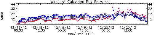
But the most interesting aspect of this is one experienced by the Houstouns and others aboard Dayton almost 170 years ago, the effect of this strong, steady wind on local water levels. Historical accounts of bad weather will often include phrases like “blew the water out of the bay,” or something similar, and that’s not much of an exaggeration. Late Thursday evening, almost 24 hours after the front went through, I collected some graphics of meteorological and hydrologic data from Houston/Galveston Bay PORTS, a reporting system built and maintained by NOAA to provide real-time updates of conditions for those in the maritime industry. The graphics are small and a little difficult to read, but they provide direct, measured documentation of the sort of event described by so many mariners and travelers over the years. The data presented here are drawn from three different locations: Morgan’s Point, where Mrs. Houstoun and Dayton were stranded for two days; Pier 21 at Galveston, at the site of what was then known as Central Wharf, the steamboat’s destination; and Galveston Bay Entrance, a buoy along the channel through which marine traffic enters and leaves all the ports in the region — Galveston, Texas City, Houston, Baytown, and so on:
![]()

![]()
Let’s look at the data in some detail:
![]()
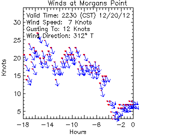 Wind speed at Morgan’s Point. This little chart shows the wind direction and speed for the period beginning about 4:30 a.m. on Thursday. The red dots show the sustained wind speed (scale on the y axis), while the blue arrows show its direction. For most of the period, right up until about 6 p.m., the wind blew steadily and consistently from the NNW at between 15 and 25 knots (17.3 to 28.8 mph), with gusts above that.
![]()
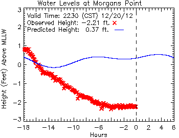
This chart shows the water levels at Morgan’s Point, from about 4:30 a.m. Thursday until late that evening. The narrow blue line represents the predicted height of the water at the tide gauge; it wavers a little bit based on the natural flow of the tide, which has a small normal range at that point. The red X marks are the actual, observed height of the water, which drops steadily with the wind over a period of about twelve hours, before leveling off and holding steady at more than two-and-a-half feet below the point known as “mean lower low water” (MLLW), the low-water standard that is used for navigational purposes. Note that the wind also wiped out almost any of the normal rise in the water level expected due to tidal action.
![]()
What about at the south end of Galveston Bay? Here’s the project vs. actual recorded water levels at Pier 21, along the Galveston wharf front:
![]()
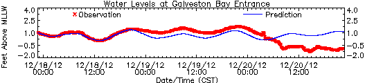
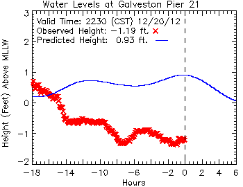 Here, closer to the Galveston Bay entrance, tidal action has more effect, but the water level remains more than two feet lower than predicted.
![]()
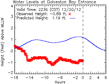
This chart, plotting data from a buoy at the entrance to the bay, reveals an almost identical profile to that from Pier 21. Here, again, eighteen hours after the passage of the front, the water remains more than two feet below its predicted level based on tides alone.
![]()
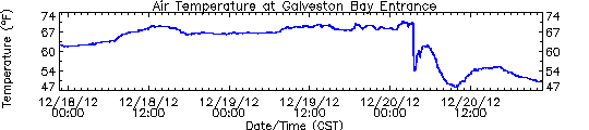
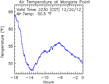
 These three charts show (top to bottom) wind speed and direction, air temperature and water levels at the entrance to Galveston Bay, for a 72-hour period ending about 10:30 p.m. on Thursday. Comparing these, it’s easy to see when the front passes in the early morning hours of Thursday, prompting dramatic changes in the wind, air temperature and water levels.
![]()
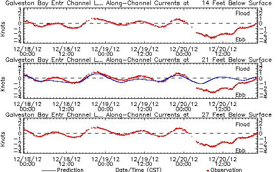 Finally, one last chart, showing the sub-surface currents at the entrance to Galveston Bay, at 14, 21 and 27 feet (4.3, 6.4 and 8.2 meters) below the surface. You can see the normal tide effect for the first 48 hours on this chart, as the current shifts between a flood tide (above the dashed line, water going into the bay), and an ebb tide (below the dashed line) as it flows out again. Although the wind only acts on the surface of the water directly, the momentum it generates there is carried through into much deeper water, dramatically altering flow of water so much that even at a depth of 27 feet, the normal tidal action is so completely erased that it results in a net ebb of the tide, a full eighteen hours of water emptying from Galveston Bay into the Gulf of Mexico.
![]()
How much water got “blown out of the bay” on this occasion? Some (very) rough estimates are possible. (Check my math, y’all.) If we take the difference between the predicted and observed water levels at the head of the bay (Morgan’s Point, -2.57 feet) and entrance to the bay (Galveston Bay Entrance, -2.08 feet), we can average between them a value of -2.33 feet. If we take that figure as representative of the water level of the bay as a whole (and that’s a big “if,” admittedly), then we can convert that vertical dimension into the volume of water it represents.
Galveston Bay encompasses about 600 square statute miles. One square mile is 27.88 million square feet; 600 square miles is 16.73 billion square feet. Multiply that by a depth of 2.33 feet, and you get a total volume of water of 38.98 billion cubic feet (1.1 billion cubic meters) of water.
That’s a lot of water; it would fill a cube-shaped aquarium 3,390 feet (1,033 meters), over a half-mile long, on each side. The water would weigh something on the order of 1.24 billion short tons, or 1.13 billion metric tonnes.
![]()
 A 3,390-foot cube of seawater, approximating the volume of water blown out of Galveston Bay during the norther on December 20, 2012. Shown to scale are (top) a large, full-rigged sailing ship similar to Cutty Sark, (right) the statue of Liberty, and (left) the Petronas Towers in Malaysia, among the world’s tallest structures.
![]()
So much for the numbers. What does this mean in practical terms for navigation on Galveston Bay? Today, weather conditions like these still pose a problem, particularly the wind, which poses significant challenges for large vessels transiting the Houston Ship Channel. I suspect the problem is worse for down-bound vessels than up-bound, as the former are running with the wind and current, and are thus much more difficult to maneuver.
In the mid-19th century, the challenges of foul weather on the bay were substantially worse. The riverboats that ran between Galveston and Buffalo Bayou, Cedar Bayou, or the mouth of the Trinity River were very vulnerable, with their high superstructures and chimneys to catch the wind from any angle. (The little sternwheeler C. K. Hall, carrying a load of bricks out of Cedar Bayou, was sunk in just such a situation in 1871.) But the bigger problem then, before major dredging operations had established a deep and stable channel, was the depth of water over obstacles like Clopper’s Bar and Red Fish Bar, a nine-mile-long oyster reef curving in a gentle, east-west arc stretching completely across Galveston Bay, almost exactly halfway between Clopper’s Bar and Galveston Island. Red Fish Bar could, on occasion, cause significant damage to vessels, and at least one steamboat, Ellen P. Frankland, would be wrecked on the obstruction in the 1840s. Both Clopper’s Bar and Red Fish Bar could be crossed regularly by vessels drawing less than four feet, but this depth of water varied with the tide and weather.
![]()
 Red Fish Bar, as shown on an 1856 chart of Galveston Bay. Soundings are given in feet.
![]()
I doubt that most of us in this area paid too much attention to the weather Thursday, apart from the inconvenience of the sudden drop in temperature and the wind. But it’s good to keep in mind how dramatically similar events sometimes affected the day-to-day lives of people in the past, and how fortunate we are to be sometimes that much more removed from them.
_____________

Canister!
Small stories that don’t merit full-length blog posts of their own:
-
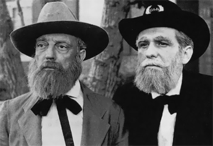
 Via Michael Lynch at Past in the Present, Glenn Beck’s favorite historian, David Barton (right), is upset that the Spielberg’s vision of the 16th president is a bit of a potty-mouth. What a dumbfuck.
- Speaking of that film, you’re probably sick of reading academic historians’ nit-picky critiques of it. (I know Keith Harris sure is.) But if you can stand to read just one more, make it Jared Frederick’s review. And if you want a copy of the final shooting script, you can download it here (PDF).
- If you’re ever on Jeopardy! and the $1,000 answer is, “this author can work Marx, Engels, Hitler, Lincoln and states’ rights into a single sentence,” the correct response is, “who is Donnie Kennedy?“
- The pissing match over display of Confederate flags at the Haywood County, North Carolina courthouse continues. There’s not a thing about this story that’s novel, except that the heritage crowd figured out a clever (if petty) legalistic solution to the ban on anything other than official government flags, by putting up a Mississippi state flag, that contains the Confederate Battle Flag as part of its design. Also, the North Dakota state flag is patterned after a 19th century U.S. Army regimental color. Just throwin’ that out there.
- The public school district in Hays County, Texas, voted this week to bar the Confederate flag from its campuses, extending a ban that had been in place since 2001 at Jack C. Hays High School. The high school’s teams will, for now, continue to be known as the Rebels, the school mascot will remain “Colonel Jack,” and the school fight song will still be “Dixie.” As with the flag dispute in Haywood County, there’s not much unusual to this story, either, except to note that the namesake of both the county and the high school, John Coffee “Jack” Hays (1817-83), was a famous Texas Ranger who sat out the Civil War quietly in California. The school’s Confederate imagery, like that of Dixie State College off Utah, is mostly an artificial construct.
- The Virginia Flaggers took a road trip to Sharpsburg recently to volunteer in placing luninarias in remembrance of those killed there in September 1862. They made a point to attend the memorial service with their big flags, unlike the other 1,400 or so volunteers, because otherwise someone might not have noticed that they were, you know, Virginia Flaggers.
- The world’s oldest person has died. Again. Have you ever noticed that they always seem to cark within a few months of claiming the title? This cannot possibly be a coincidence.
- Over at To the Sound of the Guns, Craig Swain flags a story from Ohio where the Sons of Union Veterans is fighting the proposed sale of two 3-inch Ordnance Rifles from the Civil War, that have been part of a memorial since 1927.
- Congratulations to Mads Madsen, who’s been posting his colorizations of CW images to Civil War Talk for a while now, and is finally getting some well-deserved public recognition. A lot of efforts at colorizing images yield genuinely garish results, but Madsen’s work is notable for its restraint and realism.
- As South Carolina’s governor names U.S. Representative Tim Scott to succeed Jim DeMint in the Senate, Cotton Boll Conspiracy gives us a look back to the last time a Southern state sent an African American to the upper house of Congress, back in the seventies — the eighteen-seventies.
- The Civil War Trust recently unveiled a page on Civil War Navies. Good on them; this is the sort of thing you don’t realize was sorely missing until you actually see it.
- This coming April, the SCV will raise the “World’s Biggest Third National” Confederate flag in Tampa. The event will be sponsored by the Jubal A Early Camp No. 556, even though the owner of the flag site, Marion Lambert, is a member of the new Judah P. Benjamin Camp, which sort of seceded from the Early Camp, and, well, it’s complicated.
- The lead story in Friday morning’s online edition of the Houston Chronicle was one announcing the end of the world. Brilliant, but also a tacit acknowledgement that it’s really The Onion’s world, and we just live in it.
![]()
Got any others? Put ’em in the comments below.
____________


12 comments