A Blue Norther (Revisited)
 Galveston beachfront on the morning of January 3, 2014, with much more beach exposed than is usual, due to high, steady northerly winds.

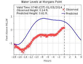
The same weather front that’s walloped the eastern United States over the last 48 hours has had its effect here on the supposedly-balmy Texas coast as well. The air temperature Thursday morning was in the mid-40s, but a sustain, 28 mph blast of wind from the north pushed the wind chill down to around freezing. The wind slacked a little during the day, but never let up completely. Sure enough, by overnight (January 2-3), the water in the upper part of the bay at Morgan’s Point had been blown down more than a foot (red Xs) from its predicted height (blue line) based on usual tidal cycles:
![]()
![]()
Under the circumstances, now seems like a good time to revisit a post I did about a year ago, on this somewhat unpleasant phenomenon.
![]()
Update, January 7: At around 8 a.m. on Monday, January 6 (“-16 hours”), the water level at Morgan’s Point was two feet below its normal level:

Cra. Zy.

In the winter of 1843-44, an Englishwoman by the name of Matilda Charlotte Houstoun (pronounced “Haweston”) visited Galveston twice with her husband, a British cavalry officer. The Houstouns were making a tour of the Gulf of Mexico, with Captain Houstoun trying to drum up interest in an invention of his for preserving beef. During their second visit, the Houstouns made a trip to Houston and back the 111-ton steamer Dayton, Captain D. S. Kelsey. On the trip back, the little steamer was delayed for two nights at Morgan’s Point, at the head of Galveston Bay, because a “norther” had blown so much water from the bay that it was impossible for the boat to get over nearby Clopper’s Bar, until the water rose again. The passengers went ashore and occupied their time in various ways; Captain Houstoun managed to shoot a possum, which was a novel creature to him. It was an object of brief curiosity until other passengers, more familiar with the fauna of Texas, appropriated it for the cook with the assurance that the animal was “first rate eating.”
![]()
 Morgan’s Point and Clopper’s Bar, as shown on an 1856 U.S. Coast Survey chart of Galveston Bay. The soundings are in feet; any unusual reduction in the water level in the bay would make the bar impassible.
![]()
“Northers” were new phenomena to the Houstouns, too, and in her travelogue Matilda Charlotte Houstoun gave a fine description of one:
They most frequently occur after a few days of damp dull weather, and generally about once a fortnight. Their approach is known by a dark bank rising on the horizon, and gradually overspreading the heavens. The storm bursts forth with wonderful suddenness and tremendous violence and generally lasts forty-eight hours; the wind after that period veers round to the east and southward, and the storm gradually abates. During the continuance of a norther, the cold is intense, and the wind so penetrating, it is almost impossible to keep oneself warm.
![]()
We had a norther here last week, a weather front that blasted through the area on the night of Wednesday/Thursday, part of the same front that caused hideous and deadly dust storms on the South Plains in Lubbock earlier. Down here, over 500 miles away, it left an orange dusting on cars and houses. Driving down to Angleton in Brazoria County along the Gulf on Thursday afternoon, my vehicle was continually buffeted by 25- to 30 mph winds, and an occasional higher gust, at a right angle to the road, pushing the car to the left, toward oncoming lanes of traffic. Not real fun.
But the most interesting aspect of this is one experienced by the Houstouns and others aboard Dayton almost 170 years ago, the effect of this strong, steady wind on local water levels. Historical accounts of bad weather will often include phrases like “blew the water out of the bay,” or something similar, and that’s not much of an exaggeration. Late Thursday evening, almost 24 hours after the front went through, I collected some graphics of meteorological and hydrologic data from Houston/Galveston Bay PORTS, a reporting system built and maintained by NOAA to provide real-time updates of conditions for those in the maritime industry. The graphics are small and a little difficult to read, but they provide direct, measured documentation of the sort of event described by so many mariners and travelers over the years. The data presented here are drawn from three different locations: Morgan’s Point, where Mrs. Houstoun and Dayton were stranded for two days; Pier 21 at Galveston, at the site of what was then known as Central Wharf, the steamboat’s destination; and Galveston Bay Entrance, a buoy along the channel through which marine traffic enters and leaves all the ports in the region — Galveston, Texas City, Houston, Baytown, and so on:
![]()

![]()
Let’s look at the data in some detail:
![]()
 Wind speed at Morgan’s Point. This little chart shows the wind direction and speed for the period beginning about 4:30 a.m. on Thursday. The red dots show the sustained wind speed (scale on the y axis), while the blue arrows show its direction. For most of the period, right up until about 6 p.m., the wind blew steadily and consistently from the NNW at between 15 and 25 knots (17.3 to 28.8 mph), with gusts above that.
![]()
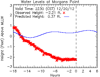
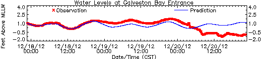
This chart shows the water levels at Morgan’s Point, from about 4:30 a.m. Thursday until late that evening. The narrow blue line represents the predicted height of the water at the tide gauge; it wavers a little bit based on the natural flow of the tide, which has a small normal range at that point. The red X marks are the actual, observed height of the water, which drops steadily with the wind over a period of about twelve hours, before leveling off and holding steady at more than two-and-a-half feet below the point known as “mean lower low water” (MLLW), the low-water standard that is used for navigational purposes. Note that the wind also wiped out almost any of the normal rise in the water level expected due to tidal action.
![]()
What about at the south end of Galveston Bay? Here’s the project vs. actual recorded water levels at Pier 21, along the Galveston wharf front:
![]()
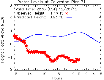 Here, closer to the Galveston Bay entrance, tidal action has more effect, but the water level remains more than two feet lower than predicted.
![]()
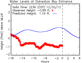
This chart, plotting data from a buoy at the entrance to the bay, reveals an almost identical profile to that from Pier 21. Here, again, eighteen hours after the passage of the front, the water remains more than two feet below its predicted level based on tides alone.
![]()
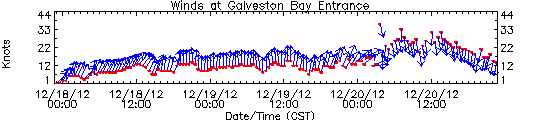
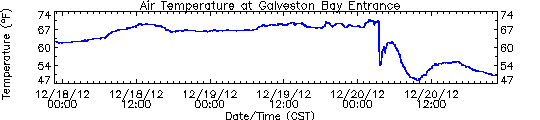
 These three charts show (top to bottom) wind speed and direction, air temperature and water levels at the entrance to Galveston Bay, for a 72-hour period ending about 10:30 p.m. on Thursday. Comparing these, it’s easy to see when the front passes in the early morning hours of Thursday, prompting dramatic changes in the wind, air temperature and water levels.
![]()
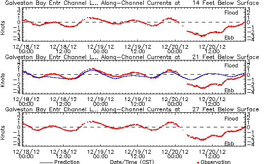 Finally, one last chart, showing the sub-surface currents at the entrance to Galveston Bay, at 14, 21 and 27 feet (4.3, 6.4 and 8.2 meters) below the surface. You can see the normal tide effect for the first 48 hours on this chart, as the current shifts between a flood tide (above the dashed line, water going into the bay), and an ebb tide (below the dashed line) as it flows out again. Although the wind only acts on the surface of the water directly, the momentum it generates there is carried through into much deeper water, dramatically altering flow of water so much that even at a depth of 27 feet, the normal tidal action is so completely erased that it results in a net ebb of the tide, a full eighteen hours of water emptying from Galveston Bay into the Gulf of Mexico.
![]()
How much water got “blown out of the bay” on this occasion? Some (very) rough estimates are possible. (Check my math, y’all.) If we take the difference between the predicted and observed water levels at the head of the bay (Morgan’s Point, -2.57 feet) and entrance to the bay (Galveston Bay Entrance, -2.08 feet), we can average between them a value of -2.33 feet. If we take that figure as representative of the water level of the bay as a whole (and that’s a big “if,” admittedly), then we can convert that vertical dimension into the volume of water it represents.
Galveston Bay encompasses about 600 square statute miles. One square mile is 27.88 million square feet; 600 square miles is 16.73 billion square feet. Multiply that by a depth of 2.33 feet, and you get a total volume of water of 38.98 billion cubic feet (1.1 billion cubic meters) of water.
That’s a lot of water; it would fill a cube-shaped aquarium 3,390 feet (1,033 meters), over a half-mile long, on each side. The water would weigh something on the order of 1.24 billion short tons, or 1.13 billion metric tonnes.
![]()
 A 3,390-foot cube of seawater, approximating the volume of water blown out of Galveston Bay during the norther on December 20, 2012. Shown to scale are (top) a large, full-rigged sailing ship similar to Cutty Sark, (right) the statue of Liberty, and (left) the Petronas Towers in Malaysia, among the world’s tallest structures.
![]()
So much for the numbers. What does this mean in practical terms for navigation on Galveston Bay? Today, weather conditions like these still pose a problem, particularly the wind, which poses significant challenges for large vessels transiting the Houston Ship Channel. I suspect the problem is worse for down-bound vessels than up-bound, as the former are running with the wind and current, and are thus much more difficult to maneuver.
In the mid-19th century, the challenges of foul weather on the bay were substantially worse. The riverboats that ran between Galveston and Buffalo Bayou, Cedar Bayou, or the mouth of the Trinity River were very vulnerable, with their high superstructures and chimneys to catch the wind from any angle. (The little sternwheeler C. K. Hall, carrying a load of bricks out of Cedar Bayou, was sunk in just such a situation in 1871.) But the bigger problem then, before major dredging operations had established a deep and stable channel, was the depth of water over obstacles like Clopper’s Bar and Red Fish Bar, a nine-mile-long oyster reef curving in a gentle, east-west arc stretching completely across Galveston Bay, almost exactly halfway between Clopper’s Bar and Galveston Island. Red Fish Bar could, on occasion, cause significant damage to vessels, and at least one steamboat, Ellen P. Frankland, would be wrecked on the obstruction in the 1840s. Both Clopper’s Bar and Red Fish Bar could be crossed regularly by vessels drawing less than four feet, but this depth of water varied with the tide and weather.
![]()
 Red Fish Bar, as shown on an 1856 chart of Galveston Bay. Soundings are given in feet.
![]()
I doubt that most of us in this area paid too much attention to the weather Thursday, apart from the inconvenience of the sudden drop in temperature and the wind. But it’s good to keep in mind how dramatically similar events sometimes affected the day-to-day lives of people in the past, and how fortunate we are to be sometimes that much more removed from them.
_____________

U.S.S. Westfield Exhibit Update

From the December 27 Houston Chronicle:
A 150-year-old Civil War ship and its contents is on its way to Texas City after being excavated from the bottom of the Houston Ship Channel and restored in a five-year project.The USS Westfield, which sank in the Battle of Galveston in 1863, was brought to the surface in 2009 in what was the largest maritime archaeological rescue project ever undertaken in Texas.Once up, archaeological conservators discovered hundreds of artifacts including belt buckles from the crew, boiler and engine parts as well as live ammunition.The star of the find is a 12-foot-long cannon, which could have fired projectiles over a mile and a half. [The gun is a IX-inch Dahlgren, the only one of Westfield’s guns not salvaged by the Confederates.]“This thing is a beast!” said Justin Parkoff, manager of the Westfield project at Texas A&M Conservation Research Lab where the restoration is taking place.
Early in 2014, that cannon will be sitting on a re-created carriage at the Texas City Museum.
Closer to summer comes a rebuild of the engine cylinder, and later in the year a massive reconstruction of the boiler. That will be so big it will reach the museum roof, Parkoff said.
“It will be a huge attraction,” said museum curator Linda Turner. “So many Civil War buffs will want to come and see it. It will be dramatic.”
Full story and lots more pictures here. Here is an image of Justin cleaning one of the boiler’s access hatches. The final phase of exhibition development will add a full-scale mockup of the boiler — half of it a modern reconstruction, and the other half assembled from original fragments recovered from the wreck. It’s gonna be fandanmtastic.

________

Dropping by to Borrow Some Dahlgrens
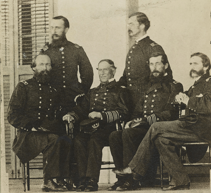
I found this image at LoC this evening. I’ve seen others taken at the same time, but not this combination of officers. The first three seated officers are (l. to r.) Army General Gordon Granger, Admiral David G. Farragut, and Farragut’s Flag Captain, Percival Drayton (of the Drayton Hall Draytons, natch). The fourth seated officer and the two standing, I don’t know. Only Farragut is identified on the LoC site.
The LoC caption is a garbled mess:
![]()
![]()
What I believe it shows is a meeting on the porch of the Commandant’s House at Fort Gaines, discussing the placement of Hartford‘s IX-inch Dahlgrens on the rear (east) side of Fort Morgan, to assist in the siege of that position. This would date the photo between August 8, 1864, when Gaines fell, and August 22, when Granger’s troops began their bombardment of Fort Morgan. Farragut and Granger got on fairly well; the admiral wrote of the general, “Granger is more of a man than I took him for, [he] attends to almost all the work so far as keeping others up to their mark.” The navy eventually lent Granger four Dahlgrens, with crews to man them from Hartford, Brooklyn, Lackawana and Richmond. Farragut also sent Lieutenant Herbert Tyson from Hartford to take charge of the guns on shore, so possibly Tyson is one of the other officers shown. The four naval guns were placed in two positions, about 1,400 and 1,500 yards from the fort’s walls, collectively designated “Battery Farragut.”
 Update, December 31: The meeting must have been prior to August 19, as well, because on that date Drayton (right) mentioned the planned battery when he wrote to an old friend, warning him not to be taken in by over-optimistic speculation in the North about the Mobile campaign:
.
However your neiqhbours feel, don’t allow yourself to be too sanguine about [the capture of the city of] Mobile. Fort Morgan has at least to be taken first, as until then not a man can be spared for anything else. We are getting a naval battery of four nine inch guns to bear upon it, but you know how difficult breaching is where the glacis entirely protects the scarp, and if the garrison has any endurance, the place must be carried by regular approaches and finally assault. At least our passage of the forts is the single piece of good luck this year. Everywhere else we have either been beaten or remained pretty much at a stand off..
Morgan actually fell four days later, without the assault anticipated by Captain Drayton, saving a great many lives on both sides.
___________
Friday Night Concert: “I Goes to Fight Mit Sigel”
“I Goes to Fight Mit Sigel” is a song that both celebrates and pokes gentle fun at the large number of German immigrants that served in the Union army. Sigel, of course, is Franz Sigel, a former Baden Army officer who had been caught up on the wrong side of the 1848 Revolution, and eventually became one of the German Forty-eighters who emigrated to the United States.
Sigel was one of Lincoln’s “political” generals, and though he didn’t make much of a field commander he was very successful in calling his fellow immigrants to Union arms, and in building the Army of the Potomac’s German regiments into a cohesive fighting unit. That is a significant contribution on its own.
![]()
I goes mit regimentals,
To Schlauch dem voes of Liberty,
Like dem ole Continentals
Vot fights mit England, long ago,
To save dat Yankee Eagle;
Und now I gets mine sojer clothes,
I’m going to fight mit Sigel. Chorus: Ya! Das ist drue, I shpeaks mit you,
I’m going to fight mit Sigel. Ven I comes from der old Countree,
I vorks somedimes at baking;
Den I keeps a lager bier saloon,
Und den I goes shoemaking;
But now I was a sojer been
To save dat Yankee Eagle;
To give dem Rebel vellers fits, I’m going to fight mit Sigel. Chorus: I gets ein tam big rifle guns,
Und puts him to mine shoulder,
Den march so bold, like a big jack-horse,
Und may been someding bolder;
I goes off mit der volunteers,
To save dat Yankee Eagle;
To Schlauch dem tam Secession volks,
I’m going to fight mit Sigel. Chorus: For rations dey gives salty pork,
I dinks dat was a great sell;
I petter likes de Sour Kraut,
De Schnitzel Kaize und Pretzel.
If Fighting Joe will give us dem,
Ve’ll save dat Yankee Eagle;
Und I’ll put mine Frau in breechaloons,
I’m go un fight mit Sigel. Chorus: Dem Deutshen mens mit Sigel’s band,
At fighting have no rival;
Un ven Cheff Davis’ mens we meet,
Ve Schlauch em like de tuyvil;
Dere’s only one ting vot I fear,
Ven pattling for dat Eagle;
Ve vont get not no lager bier,
Ven ve goes to fight mit Sigel! Chorus:
__________
Mapping Speech
![]()
 So said Henry Higgins in the first act of George Bernard Shaw’s Pygmalion. The New York Times Sunday Review has a short, 25-item quiz on vocabulary and pronunciation of specific words, that compares users’ speech to that of other people around the United States.
According to the survey, my own vocabulary and pronunciation is closest to other folks that live in the area shown in dark red:

The major cities my speech most closely matched were Houston (“feeder road” is apparently a term unique to the Houston metro area), Baton Rouge, and New Orleans. Users should remember that this survey doesn’t claim to predict where you’re from, but how similar your pronunciation and usage are to people in different parts of the country. Still, for me, that looks about right. How about you?
____________
Image: Julie Andrews and Rex Harrison in the Broadway production of My Fair Lady.
Christmas Picket

One hundred fifty-two years ago today, a nineteen-year-old Confederate soldier named Valerius Cincinnatus Giles (right, 1842-1915) went out on picket duty along the Potomac.
On Christmas morning a detail of twenty men was sent from the Fourth Texas Regiment to relieve the picket guard along the river. This detail was commanded by Lieutenant R. J. Lambert. The post assigned me was on Cock Pit Point, about 100 yards from the masked battery. This battery of four guns was planted twenty feet back from the edge of the bluff, completely hidden from view by an abatis of pine brush felled and stacked, with the sharpened ends of the trunks pointing outward. as a crude defense. From my post I had a splendid view of the river for two or three miles in each direction. The low range of hills on the Maryland side opposite were covered with white tents and log cabins, the winter quarter of General Daniel E. Sickles’s New York Brigade. The war had just fairly begun, and this was new to me. The novelty of the situation, the magnificent view before me, the river rolling majestically along between white hills and evergreen pines so charmed and captivated me at first that I felt not the bitter cold. The snow was gently and silently falling, deepening the hills and valleys, melting as it struck the cold bosom of the dark river. I had been on post but a short time when I beard the signal corps man sing out from the crow’s-nest high up in a sawed-off pine tree, saying to the officer in charge: “Look out, Lieutenant, a gun boat is coming down the river!” I could hear the artillery officer giving orders to his men, but from my position I could not see them. Looking up the river I saw a cloud of black smoke rising above the tops of the trees. All was excitement at the battery, and I could hear the artillerymen ramming home their shells, preparing to sink the approaching boat. Directly the steamer turned a bend in the river with volumes of black smoke pouring from her smokestacks. She was in the middle of the stream, coming dead ahead under full steam. It was really a disappointment to the fellows at the battery as well as myself, when the soldier in the crow’s-nest called out again: “0h, pshaw, Lieutenant, don’t shoot! She’s nothing but an old hospital boat, covered over with ‘yaller’ flags.” Of course a Confederate battery would not fire on a yellow flag any more than on a white one. The boat came steadily on down the river until she got nearly opposite Cock Pit Point, when she blew her whistle and turned toward the Maryland shore. As she made the turn she came within 200 yards of the Virginia bank and I could distinctly read her name on the wheel house. It was the old Harriet Lane, named in honor of the accomplished niece of President James Buchanan, who was queen of the White House during the administration of that eccentric old bachelor. In the winter of 1861 the Harriet Lane was in the employ of the Hospital Corps of the Army of the Potomac. A few days after that, she left her mooring on the Maryland side and pulled out down the river. She subsequently became a warship of some kind and met defeat at the Battle of Galveston in January, 1863. After the boat bad landed and the excitement was over, a melancholy stillness settled around me. The novelty and fascination of my surroundings soon lost their charm. The lowering clouds above me and the white silence about me became monotonous and I began to feel restless and uneasy. If you are in a forest or on a prairie on a still summer day and will stop and listen attentively, you can bear the songs of birds, the chirping of crickets or the drowsy hum of insects. hut in a piney woods in midwinter, when the earth and green branches of the trees are covered with snow, with not a breath of air blowing, the stillness is oppressive. I must have bad a slight attack of homesickness, for I began to think of home and my mother and father away out in Texas waiting and praying for the safe return of their three boys, all in the army and all in different parts of the Confederacy — one in the Tenth Texas Infantry at an Arkansas post, one in Tennessee or Kentucky with Terry’s Rangers, and one in the Fourth Texas Infantry in Virginia. . . . While I stood at my post on the banks of the Potomac I knew I was perfectly safe from any personal danger, yet something seemed to warn me of approaching evil. I tramped through the snow, half-knee-deep, although I was not required to walk my beat. I tried to divert my mind from the gloomy thoughts that possessed me, but all in vain. Suddenly I was startled from my sad reflections of home and kindred by distinctly hearing a voice I new — my brother Lew’s voice — calling my name. I turned quickly, looked in every direction, heard nothing more and saw nothing but the white world around me and the dark river below me. He was two years my senior, had been my constant companion and playmate up to the beginning of the war. It was then 4 P.M., December 25, 1861. I was not sleeping or dreaming. and firmly believed at the time that I heard my brother calling me, but it must have been a delusion of the imagination. However, Lewis L. Giles of Terry’s Texas Rangers, Troop D, Eighth Texas Cavalry, was mortally wounded at the battle of Mumfordsville, [Woodsonville] Kentucky, December 17, 1861, in the same charge in which Colonel Terry was killed. He was removed by his comrades to Gallatin, Tennessee. and died at the residence of Captain John G. Turner, a lifelong friend of my father. He breathed his last precisely at four o’clock on Christmas Day. 1861, while I stood picket on the banks of the Potomac.[1]

A Sherlock Christmas Cracker

We’re off for Christmas dinner today with family (traditionally on Christmas Eve for us, for reasons I’ve forgotten), so in the meantime, here’s a Christmas cracker courtesy of the BBC, teasing the upcoming third season of Sherlock. If you’re a fan but haven’t seen Season 2, there are spoilers in this clip. (Actually, the whole clip is one long spoiler.) If you haven’t seen the series, but want to get a sense of it, here’ s John Watson’s first encounter with the famous consulting detective:
![]()
![]()
Have a wonderful and joyous holiday!
__________
The Disappearance of “Bitter Bierce”
Bierce returned to Indiana to answer Lincoln’s call for troops in April 1861. When his three-month stint was up, he signed on for two years more. Rising steadily in rank and cited often for valor, he remained in uniform for the rest of the Civil War. Little of the experience of war escaped him: shameless retreats, hopeless charges, courage, stupidity, confusion, terror, camaraderie, and endless slaughter. He was wounded at least twice before the battle of Kennesaw Mountain, when a bullet to the left temple lodged behind his ear, cracking his head open “like a walnut,” he wrote later, in a phrase that captures his peculiar blend of detachment and precision. Eventually he was forced to return to Indiana for convalescence. He left again as soon as he could. By then the war was effectively over, though of course he could never quite get over it. His rise from enlisted man to officer gave Bierce a vertical view of how men made decisions of life and death under the most miserable conditions. What he saw year after year only confirmed his native cynicism. Stupidity made a deeper impression on him than physical courage, perhaps because he himself had so much more of the latter than the former. The blundering of generals fed his distrust of authority.
And on his disgust with the excesses of the Gilded Age:
The best-known adventure from his newspapering was also the least typical. He and [his employer, William Randolph] Hearst had nothing in common politically except a vague revulsion for the crony capitalism of the Gilded Age and a more pointed hatred for the cronies themselves. The fattest target among the Railrogues, as Bierce called them, was Collis P. Huntington, chairman of the Southern and Central Pacific railroads, and the richest man in California. A useful percentage of Huntington’s fortune fell into the pockets of congressmen and senators in Washington, and when Congress floated a bill relieving him and his railroad of a $75 million debt to the federal government (a loan on which Huntington’s riches had been built), it was assumed that it would pass easily. Hearst’s newspapers exploded. The publisher sent Bierce to Washington to front a relentless campaign to kill Huntington’s bill. Bierce directed a team of reporters and wrote every day himself, sometimes twice a day, always in high spirits: “Mr. Huntington is not altogether bad,” went a throwaway line in a typical column. “He says ugly things of the enemy, but he has the tenderness to be careful that they are mostly lies.” Incredibly, after months of daily coverage, Bierce and Hearst succeeded—an early sign that the Gilded Age had run its course. The bill was withdrawn, though not before Huntington confronted Bierce on the steps of the Capitol among a scrum of reporters. “Name your price,” Huntington demanded, insisting that Bierce call off his campaign. “Every man has a price.” “My price,” Bierce responded cinematically, “is $75 million, handed over to the Treasury of the United States.”
Go read the whole thing. Bierce, of course, is a favorite of mine. Bierce’s disdain for shoddy historians of the war is made evident here, his views on black soldiering here, on Grant’s drinking habits here, and the most frequent invocation of God in battle, here.
Not Surprising, Part Deux
Recently Michael Rodgers reminded me of this post from 2011, in which I pointed out the very tight correlation (beyond -0.9, for y’all stats wonks) between the order in which the states that formed the Confederacy seceded, and both the proportion of slaves and the proportion of slaveholders in their total population. It’s based on a table compiled by David C. Hanson of Virginia Western Community College, and came to my attention via Donald R. Shaffer’s Civil War Emancipation blog. It makes a fundamental point but, in tabular format, the point may not be obvious to all. At the time, Shaffer wrote that “Hanson makes a definite connection between the concentration of slaves and slaveholders in a particular southern states and when it seceded from the Union in 1860-61, and whether it seceded at all. Certainly, there is plenty of anecdotal evidence connecting slavery and Civil War causation, but this table also makes a compelling statistical case.”
It’s more than a “definite connection.” Hanson’s simple data set reveals that for the eleven states that actually seceded, the proportion of free persons owning slaves was an excellent predictor of the order in which they seceded, beginning with South Carolina (highest proportion of slaves and slaveholders) and ending with Tennessee (low proportions of both). The percentage of slaves as part of the state’s overall population was equally reliable as a predictor. In short, each percentage is a nearly perfect predictor of where each state falls in the order of secession. The states with the largest proportions of slaves and slave-holders seceded earliest.
Anyway, back to data presentation: here’s Hanson’s data shown in two simple bar charts. There is absolutely a clear pattern in both cases; if slaves and slaveholding were not connected to the timing of each state’s secession, the tall and short columns would be randomly scattered. They’re not.


__________


5 comments